Inland Flooding
Overview
Developed by the OPW, floodinfo.ie provides access to river and coastal flood extents. This includes information on current flood extent and future flood extents that account for the effects of climate change
- Ireland has been subject to a number of major flood events around the country over the last decade and climate change is likely to result in increased flood risk.
- There still remain large uncertainties in projections of future precipitation for Ireland and these uncertainties are exacerbated when employed in projecting hydrological response to climate change. Nonetheless, projections for Ireland indicate an increased level of flood risk during the winter months.
- Areas already at risk of flooding can be expected to be at increased flood risk while areas currently not prone to flood risk may become more prone to flooding in the future. This is particularly the case for those areas located at the confluence of major rivers.
- These changes raise concerns regarding the integrity of flood defences, the capacity of the urban drainage system, the need for greater concerning planning and development of vulnerable areas as well as insurance implications for commercial and private properties.
Current exposure
For Ireland, the occurrence of inland flooding is now quite widespread and includes all Inland Flooding Types. Over the recent past, flood risk has been exacerbated through the new development of lands. For example, development on flood plains has altered flow routes and the volume available for flood storage. In addition, changes in land management and introducing surfaces with reduced permeability, such as roads, roofs and car parks has resulted in decreased absorption capacity and increased runoff rates.
River and groundwater flooding
River and groundwater flooding is particularly prominent in the west of Ireland, e.g. the Shannon estuary, where levels of runoff are relatively high reflecting the east-west gradient in precipitation. In addition, levels of runoff from uplands are relatively high reflecting localised increases in precipitation due to orographic effects.
Estuarial flooding
Estuarial flooding forms a key risk for Ireland's cities and this was strongly demonstrated over winter 2013/2014 (Storm Darwin) when a combination of high tides, strong winds and heavy rainfall led to the widespread estuarial flooding. This period can be considered as exceptional and has been identified as being the stormiest for at least 143 years when storm frequency and intensity are considered together.
Flooding from artificial drainage systems
Flooding can also arise from the failure of infrastructure designed to store or carry water or to protect an area against flooding. As a result, existing flood defences which have been designed based on past flood events must now be re-appraised in the context of climate change.
Floodinfo.ie has been developed by the OPW and provides access to Flood Plans and Maps for the purposes of flood risk management
Future exposure
Long-term records of river-flow for Ireland indicate an increasing trend for all seasons, this is particularly the case for annual and winter high flows. Projected climate data for Ireland suggests that this trend will continue into the future and will have a direct impact on levels of flood risk.
Projected changes in precipitation
Projected changes in precipitation for Ireland show a relatively high degree of uncertainty with individual models exhibiting differences in the extent and spatial distributions of projected precipitation. However, there is agreement in the overall direction of change which suggest that precipitation will become increasingly seasonal with winter becoming significantly wetter by the mid to late 20th century and summers drier. In addition and more importantly, the occurrence of extreme precipitation events is projected to increase.
Projected changes in flood risk
In order to assess how climate change will affect the frequency and magnitude of inland flooding, projected climate data is employed to drive hydrological models that have been developed/parameterised for specific catchments. However, the employment of hydrological models amplifies the already considerable uncertainty implicit to climate modelling. Nonetheless, projected changes in hydrological regimes have been developed for a wide range of catchments in Ireland and a number of consistent signals for changes in hydrological regimes most prominently driven by changes in precipitation patterns are apparent.
Overall, modelling results indicate that increased precipitation will result in substantial increases in winter and spring stream flow for all of the catchments assessed and, as a result, an elevated risk of flooding. For winter, and by the mid to late century, an increase of up to 20% in the amount of water flowing in rivers can be expected with the greatest increases in January and February.
In addition, and of importance in the case of flood risk management, modelling results also indicate that the occurrence of extreme flood events will increase and that the impact of climate change on flood behaviour is higher for low frequency events (floods with a return period of 100 years) than for high frequency events (floods with return periods of 5 years). For example, for the Blackwater, it is projected that by mid-century, the current 40 year return period is likely to be associated with a 9 year recurrence interval. A recent Europe wide study indicates that flood events that currently have a return period of once in a hundred years will increase for Ireland's major rivers as the century progresses.
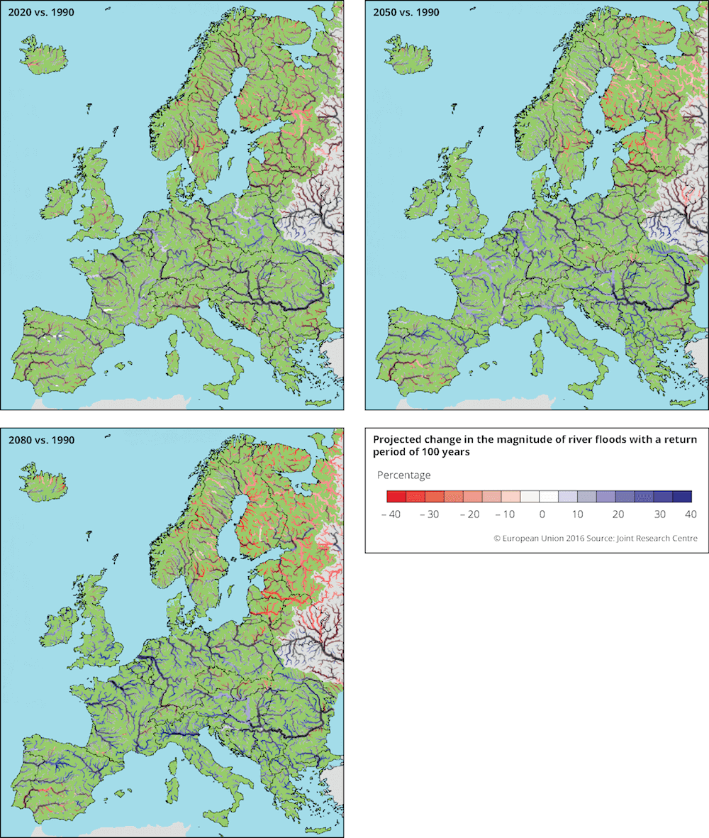
Projected change in the magnitude of river floods with a return period of 100 years [EEA, 2016].
Implication for management
The projected increase in magnitude and frequency of precipitation and resulting flood events would suggest significant impacts for areas already at risk of flooding. In addition, projected changes indicate that areas currently not prone to flood risk may become more susceptible to flooding in the future. This is particularly the case for those areas located at the confluence of major rivers or around estuaries, where increased sea level rise in combination with increased river outflow may cause extensive estuarine flooding. These changes raise concerns regarding the integrity of flood defences, the capacity of the urban drainage system, the need for greater concerning planning and development of vulnerable areas as well as insurance implications for commercial and private properties.
In the short term, a number of measures may be taken that are both flexible and robust:
- Developing an understanding of flood risk is an essential first step in managing the impacts of flooding and in making informed decisions;
- Flood risk must be a key consideration in preparing development plans and local area plans and in the assessment of planning applications;
- Inappropriate development should be prohibited in areas that are at high risk of flooding, e.g. flood plains or areas that area already prone to flooding;
- Areas identified at risk of future flooding should be delineated and suitable guidance should be provided.
Click here to access: The Planning System and Flood Risk Management - Guideline for Planning Authorities
In the medium to long term, and as fixed design standards are no longer relevant:
- Existing flood protection schemes and water infrastructure should be assessed against the full range of climate scenarios;
- Adopt a sequential approach to flood risk management when assessing the location for new development based on avoidance, reduction and mitigation of flood risk;
- Planned flood protection schemes and all water infrastructure projects, e.g. drainage schemes, should be assessed against the full range of climate scenarios and should be flexible so as they can be adapted in the future as more information becomes available.